
Desilting of the headrace at the Inga I and II hydropower complex
The headrace at the Inga development, the DRC’s flagship hydropower scheme on the Congo river, had been silted up for many years, limiting its production capacity. The SNEL and Artelia studied this serious issue together to identify the best long-term solution for desilting.
Context
Inga I and II hydropower complex (Democratic Republic of the Congo) - Client: SNEL - Scales: V=1:100; H=1:140
In the context of the plan to develop and harness the hydroelectric potential of the Inga scheme on the Congo river, the country’s electricity company (SNEL) intended to rehabilitate the existing Inga I and Inga II facilities, which were built in the 1970s, and thus commissioned Artelia to perform a physical model study of the possibilities for desilting the headrace in order to increase the production flow rate.
Purposes of the physical modelling
The purpose of the model was to comprehend the issue that was limiting the inflow to the 2 existing powerhouses, Inga I and Inga II, located at the end of a headrace approximately 10 km in length.
Physical modelling not only allowed the best solution for desilting the headrace and keeping it silt-free to be identified, but also revealed a flow rate limitation due to insufficient excavation of the headrace during works in the 1970s. The model thus validated the design of the structures required and the operating modes defined to desilt the headrace.
Since this exceptionally large emblematic model was created in our Laboratory, the full-size works have been implemented on the Inga site under the supervision of Artelia, and the headrace is now ready to convey a higher flow rate to the turbines in order to increase hydropower production.
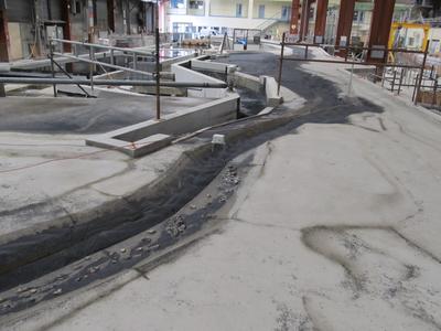
Description of the model
This exceptionally long model (80 m) represents:
- the Congo river in the vicinity of the water intake, over a length of around 3 km,
- the complete diversion canal, over a distance of approximately 10 km,
- the side closure dams, relief weirs and hydropower water intakes on Inga I and II,
- sediment transport in the river,
- annual flood hydrographs of the river.
| Design flow rates | Length of headrace | Height of dams |
|
Mean annual discharge: 40,000 m3/s Flood: 80,000 m3/s Turbine flow rate: 3,600 m3/s |
10 km | 50 m |